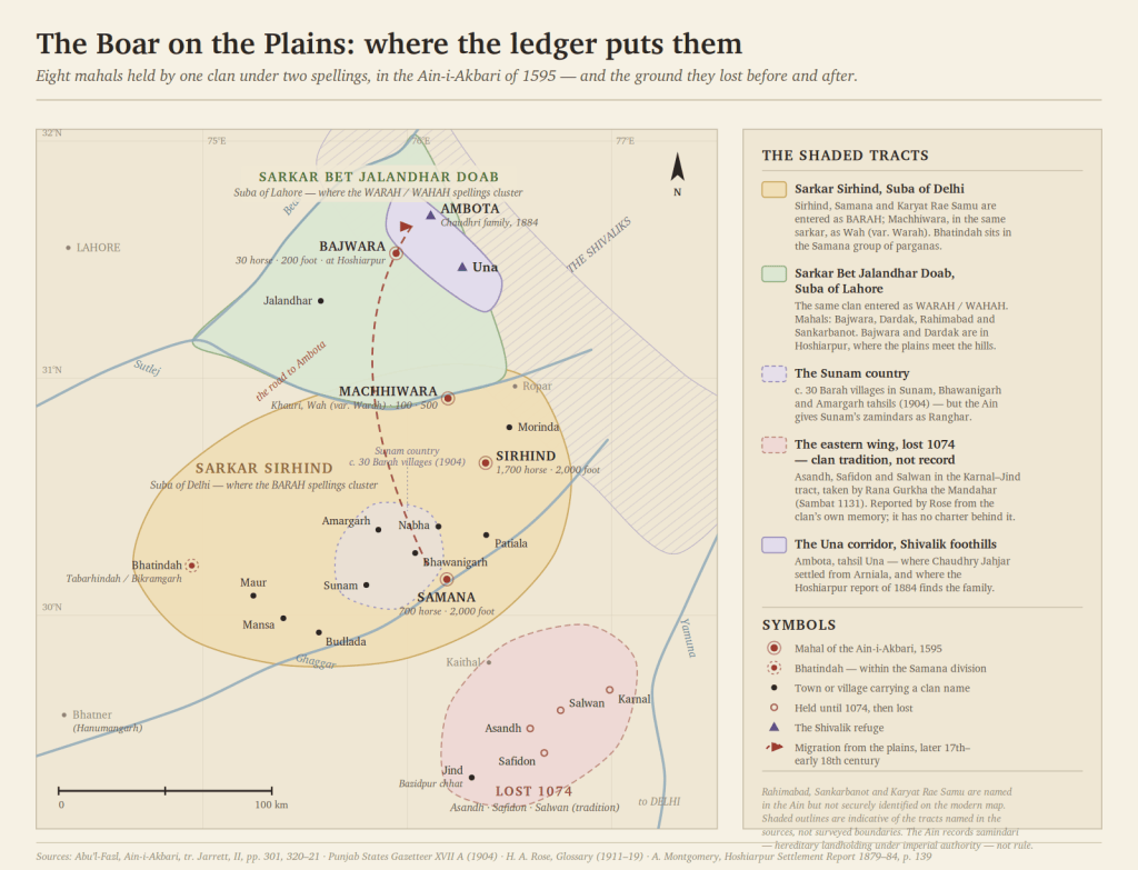
On a clan that held Samana and Sirhind, the cities they left their names on, the century in which they lost the plains, and the road that led to a Shivalik village called Ambota.
There is a particular kind of silence in Indian history. Not the silence of a people who left nothing, but the silence of a people whose records were kept by someone else — by the bards of the clan that displaced them, by the revenue clerks of the empire that taxed them, by the district officers of the government that finally counted them. You find such a people not in the chronicles, where the winners are, but in the columns. In the ledgers. In the caste entry beside a village name.
The Varaha of the Punjab are such a people. And in the summer of 1595, in a set of tables compiled for the Emperor Akbar, they are there in black ink.
I. The Column in the Ledger
Abu’l-Fazl’s Ain-i-Akbari is not a chronicle. It is an administrative survey — the most detailed accounting of an Indian empire made before the colonial censuses. For each mahal, the smallest fiscal unit, it records the assessed area in bighas, the revenue in dams, the charitable grants, and then two columns that historians have mined for four centuries: the cavalry and infantry the tract could raise, and the castes of its zamindars — the hereditary landholding body that collected the revenue and kept armed men.
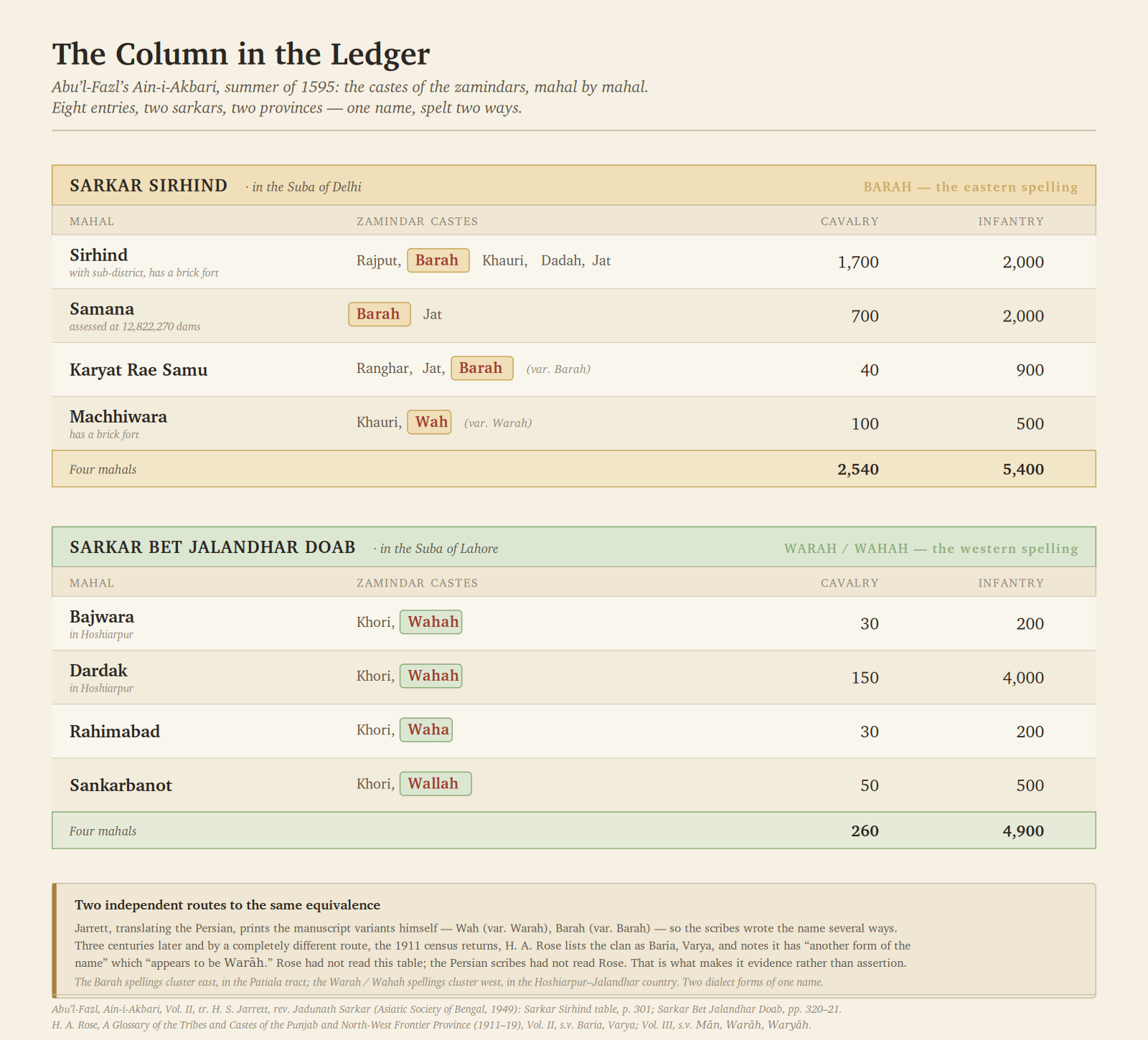
Turn to the table for Sarkar Sirhind, in the Suba of Delhi. The entries read:
| Mahal | Zamindar castes | Cavalry | Infantry |
|---|---|---|---|
| Sirhind, with sub-district, has a brick fort | Rajput, Barah, Khauri, Dadah, Jat | 1,700 | 2,000 |
| Samana | Barah, Jat | 700 | 2,000 |
| Karyat Rae Samu | Ranghar, Jat, Barah (var. Barah) | 40 | 900 |
| Machhiwara, has a brick fort | Khauri, Wah (var. Warah) | 100 | 500 |
Now turn west, across the Sutlej, to Sarkar Bet Jalandhar Doab in the Suba of Lahore:
| Mahal | Zamindar castes | Cavalry | Infantry |
|---|---|---|---|
| Bajwara | Khori, Wahah | 30 | 200 |
| Dardak | Khori, Wahah | 150 | 4,000 |
| Rahimabad | Khori, Waha | 30 | 200 |
| Sankarbanot | Khori, Wallah | 50 | 500 |
Eight mahals, across two sarkars, in two different provinces of the empire.
Two things deserve notice. The first is that Jarrett, translating the Persian, prints the manuscript variants himself: Wah (var. Warah), Barah (var. Barah). He is telling us the scribes wrote the name several ways. Three centuries later, and by a completely different route — the 1911 census returns — H. A. Rose would write in his Glossary of the Tribes and Castes of the Punjab that the clan he lists as Baria, Varya has “another form of the name” which “appears to be Warāh.” Rose had not read this table. The Persian scribes had not read Rose. They arrived at the same equivalence independently, and that is what makes it evidence rather than assertion.
The second is geography. The Barah spellings cluster east, in Sarkar Sirhind — the Patiala tract. The Warah / Wahah spellings cluster west, in the Bet Jalandhar Doab — the Hoshiarpur–Jalandhar country. Two dialect forms of one name, in two adjacent administrative provinces. Hold that thought; it matters later.
II. Samana Before Delhi
To understand what the Samana entry means, you have to unlearn the modern map.
In the thirteenth and fourteenth centuries the important places of the eastern Punjab were not the towns we now think of. They were Samana, Sunam, Sirhind and Kaithal — the belt of walled towns strung along the road from Delhi to Lahore, each with its fort, its garrison and its assessed tract. This road carried every army that ever went either way. Samana sat on it.
Its weight in the Sultanate is easily shown. Bughra Khan, the younger son of Sultan Ghiyas-ud-din Balban and later Sultan of Bengal in his own right, held Samana and Sunam in fief — the appanage given to a prince of the blood. Earlier the same territory had been assigned to Sher Khan, Iltutmish’s page, and then to Timar Khan. These are not the fiefs of minor towns.
And in Akbar’s survey, four centuries on, Samana is assessed at 12,822,270 dams — a figure of the same order as Sirhind itself — with 700 horse and 2,000 foot. Its zamindars are named as two castes only: Barah, Jat.
Local tradition, recorded in the Phulkian States Gazetteer of 1904, adds what the ledgers do not: that Samana’s “original name is said to have been Nagnian Khera during the rule of Barah Rajputs.”
A word of discipline here, because it costs nothing and protects everything. The Ain’s caste column records zamindari — hereditary landholding, revenue collection, armed retainers under imperial authority. It is documented territorial power of a substantial kind. It is not sovereignty, and no inscription or coin names a Barah king. The claim of rule at Samana comes from local memory, not from the record. Both are worth having. They are not the same thing, and a clan’s case is stronger, not weaker, for saying so.
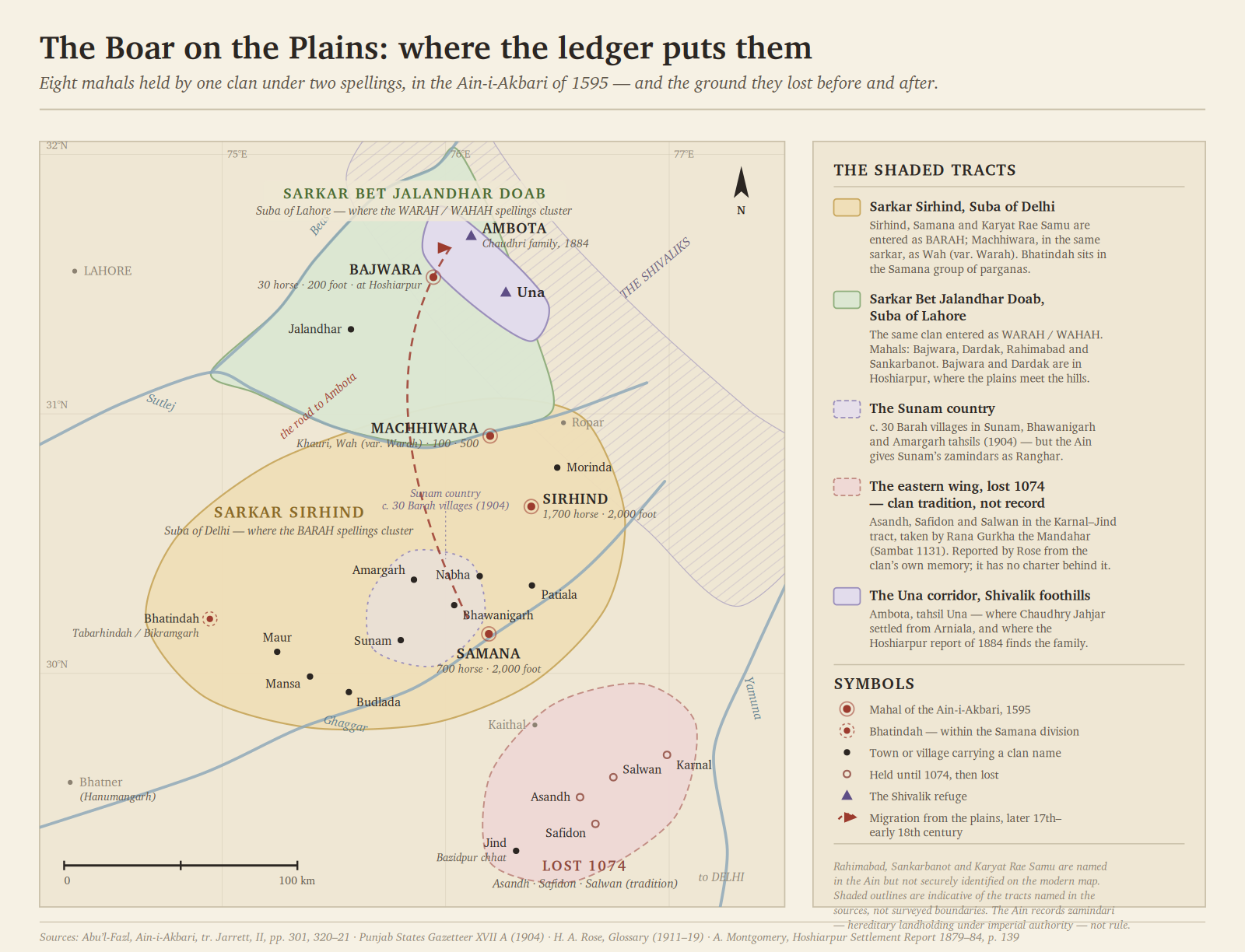
And Sunam is a genuine exception that should be stated plainly. The Ain gives Sunam’s zamindars as Ranghar — not Barah. What is true, and separately documented, is that the Phulkian States Gazetteer records the Barah owning nearly thirty villages in the tahsils of Sunam, Bhawanigarh and Amargarh. They were thick on the ground in the Sunam country. They were not, in 1595, its zamindar caste. The distinction is the sort a critic finds in an afternoon, so it is better made by us.
III. What Bhatinda Was Called, and Who Named It
The Ain groups the parganas of the Samana division as: “Samanah, Sunnam, Mansurpur, Malner, Hapuri, Pundri, Fatehpur and Bhatindah, Machhipur.”
Bhatinda sits inside the Samana group — the mahal whose zamindars are Barah and Jat.
The fort itself has carried a remarkable number of names, and they are worth setting out because they are so often confused: Tabarhindah and Tabarhind in the Persian chronicles; Batrinda in Ibn Battuta; Bikramgarh or Vikramgarh as the pre-Islamic name given in Khalifa Muhammad Hassan’s History of Patiala; Tiranda in Garrick’s archaeological report of 1885; and Govindgarh after the Patiala acquisition.
Into this clan tradition inserts a founder. Rose records that the Warah descend from Warah, “whose grandson Rājā Banni Pāl is said to have founded Bhatinda, after conquering Bhatner and marrying the daughter of its Rājā.” The Phulkian Gazetteer, collecting from the Barah themselves, says they “claim descent from Binepal of Bhatinda.”
Banni Pal has no coin and no inscription. He is a bardic eponym — the name a tract gives to its own beginning. That is what such founders usually are, in every clan’s memory, and it is no discredit to the clan that it is so.
IV. The Cities That Carry the Names
Here is the part that survives longest, because place-names outlast dynasties by centuries.
Rose’s footnote to the Mān entry preserves a division of the inheritance: “Bani Pāl had 4 sons, Parga, Bandar, Khalā and Maur, of whom the first settled in Nabha.”
Set that beside the Phulkian States Gazetteer, working from an entirely different informant, which records the chief sub-septs of the tract as Maur, Sandar, Khawala and Pargra — “and they give their names to the villages of Maur, Manwala, Man Khera and Mansa.”
The same four names, in the same order, functioning as territorial divisions. These are not four brothers. They are four sub-districts, and the pedigree is the map turned into a genealogy — which is precisely how pre-modern tracts remembered their own partition.
So the cities on the ground today:
- Maur — now Maur Mandi, in Bathinda district
- Mansa — now a district headquarters
- Manwala and Man Khera — the smaller settlements of the same division
- Badbar, in Nabha — Rose says Sundar’s eldest son “founded Badhar in Nābha,” and the Phulkian Gazetteer, independently, lists Badbar as one of the three Barah chhats of Nabha, with Baena and Baragraon. Two sources, two routes, one village.
- Samana — remembered as Nagnian Khera before them
And the clan’s own territorial skeleton, as the 1904 gazetteer records it: twelve chhats — villages of the first rank — being Samana, Talwandi, Kakri, Bhumsi, Jhal and Jhondan in Patiala; Baena, Badbar and Baragraon in Nabha; Bazidpur in Jind; and Budlada and Morinda in British territory. Twenty-four makans of the second rank below them.
One caution, since it will be raised. In Hindi barah means twelve, and Tod’s “Barah-kothri” of Amber is simply the twelve great fiefs of Jaipur — nothing to do with this clan. What settles the matter here is that the Ain lists Barah in a caste column, beside Rajput, Khauri, Jat and Ranghar. It is a name, not a number.
V. Who Took the Plains
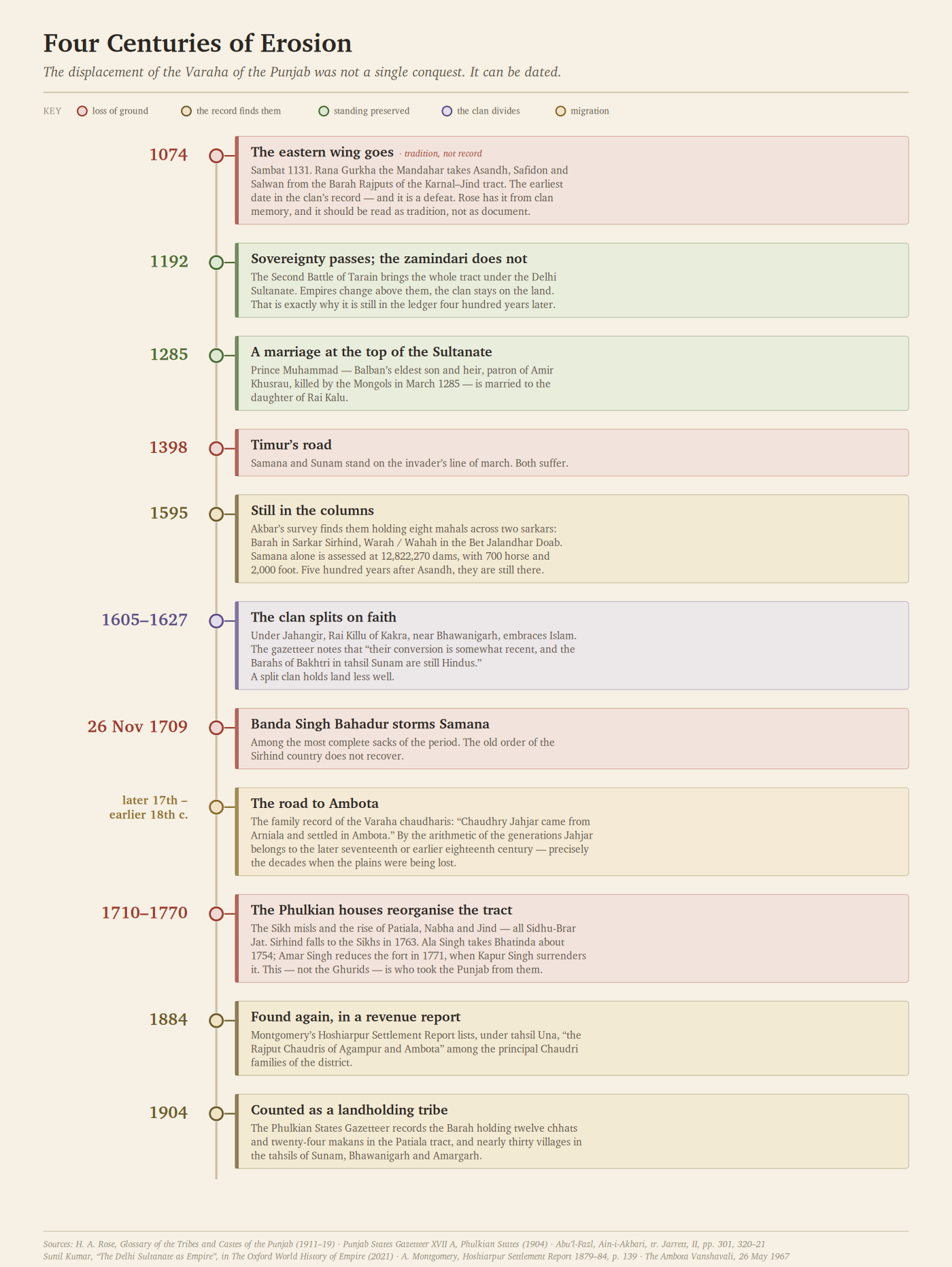
The displacement was not a single conquest. It was four centuries of erosion, and it can be dated.
1074 (Sambat 1131). The earliest firm date in the clan’s record, and it is a defeat. Rose reports that the Barah Rajputs held the country round Asandh, Safidon and Salwan in the Karnal–Jind tract, and that Rana Gurkha the Mandahar took the three forts from them, settling at Asandh. The eastern wing is gone.
1192. The Second Battle of Tarain. Muhammad of Ghor’s victory brings the whole tract under the Delhi Sultanate. Sovereignty passes — but the zamindari does not. This is the crucial distinction: empires changed above them and the clan stayed on the land, which is exactly why it is still in the ledger four hundred years later.
1285. A marriage that shows the clan’s standing under the Sultanate. Prince Muhammad, Balban’s eldest son and heir — patron of Amir Khusrau, killed by the Mongols in March 1285 — was married to the daughter of Rai Kalu. The fact is recorded not in clan tradition but in modern scholarship: Sunil Kumar’s chapter in The Oxford World History of Empire (2021) cites it as an instance of Hindu participation in the Sultanate that the Persian chronicles otherwise obscure.
1398. Timur’s invasion. Samana and Sunam are on his road, and both suffer.
1595. Akbar’s survey finds them still holding eight mahals. Five hundred years after Asandh, they are still in the columns.
1605–1627. Under Jahangir, Rai Killu of Kakra, near Bhawanigarh, embraces Islam. The gazetteer notes carefully that “their conversion is somewhat recent, and the Barahs of Bakhtri in tahsil Sunam are still Hindus.” The clan splits along the line of faith, and a split clan holds land less well.
26 November 1709. Banda Singh Bahadur storms Samana. The sack is among the most complete of the period. The old order of the Sirhind country does not recover.
1710–1770. The decisive change. The Sikh misls and the rise of the Phulkian houses — Patiala, Nabha, Jind, all Sidhu-Brar Jat — reorganise the whole tract. Sirhind falls to the Sikhs in 1763. Ala Singh takes Bhatinda about 1754; Amar Singh reduces the fort in 1771, when Kapur Singh surrenders it.
That is the answer to who took the Punjab from them. Not the Ghurids, who only took the sovereignty. The Sidhu-Brar Jats of the Phulkian states, in the eighteenth century — the ancestors of the very durbars whose gazetteer would later, in 1904, record the Barah as a landholding tribe of thirty villages.
VI. The Road to Ambota
Now return to that second cluster in the Ain — the Warah / Wahah entries in the Bet Jalandhar Doab: Bajwara, Dardak, Rahimabad, Sankarbanot. Bajwara is in Hoshiarpur. Dardak is in Hoshiarpur. This is the sub-montane country where the plains run up against the Shivaliks.
It is also the corridor to Una.
The family record of the Varaha chaudharis of Ambota, in the Una district of Himachal Pradesh, preserves a migration in a single line: Chaudhry Jahjar came from Arniala and settled in Ambota. By the arithmetic of the generations that follow him in that record, Jahjar belongs to the later seventeenth or earlier eighteenth century — which places the move in precisely the decades when the plains were being lost: after the conversions, around the sack of Samana, as the misls rose.
A clan pushed off the open plain moves to the hills. It is the oldest pattern in North Indian settlement history.
And the arrival is independently recorded. In the Final Report of the Revised Settlement of the Hoshiarpur District, 1879–84, Mr Montgomery lists the leading families of each tahsil. Under Una he writes:
“The principal Chaudri families are:— In tahsil Una the Rajput Chaudris of Agampur and Ambota, and the Brahmins of Takarla in Talhatti.”
A government revenue officer, with no interest in any clan’s pedigree, recording the family at Ambota as one of the principal Chaudhri houses of the district. The same report notes a fair held at Ambota in Baisakh, in a grove called Shiban-ki-Lari — the Shiv Bari — attended by about a thousand people.
From the zamindari of Samana in 1595 to a Chaudhri family in a Shivalik village in 1884: it is not a story of grandeur. It is the ordinary shape of what happens to a landholding clan that loses its plain. But it is documented at both ends, and there are not many Punjab lineages of which that can be said.
VII. What Can Be Said, and What Cannot
Since the whole value of this account is that it can be checked, let it be explicit.
What the documents establish. A clan named Barah in the east and Warah in the west held the zamindari of eight mahals across two sarkars in 1595, including Samana with 700 horse and 2,000 foot, and Sirhind. They held some thirty villages, twelve chhats and twenty-four makans in the Patiala tract into the twentieth century. Rose independently records Warah and Waryah as Rajput clans in Montgomery and Amritsar and Baria/Varya in Patiala, Nabha, Jullundur and Sialkot. A Barah chief’s daughter married the heir to the Delhi Sultanate in 1285. Their conversion at Kakra is dated to Jahangir’s reign. The family at Ambota is in the Hoshiarpur settlement record of 1884.
What tradition says, and should be labelled as tradition. That Samana was Nagnian Khera under their rule. That Banni Pal founded Bhatinda after taking Bhatner. That a Barah chief once seized the Bhatinda fort. That they held Asandh, Safidon and Salwan until 1074.
What remains unresolved, and should be stated as such. The clan’s own origin traditions do not agree with one another. The Barias of Jullundur claimed Solar descent from Raja Karan; those of Sialkot claimed Lunar; the Mān tradition makes Binepal the last ruler of Ghazni; and the Barah told the gazetteer officers in 1904 that they had “emigrated at a very distant period from Udaipur.” Four irreconcilable origins for one clan. The honest reading is that these are prestige-origin claims of the ordinary kind, and that the clan’s real antiquity has to be argued from the ledgers and the villages, not from the pedigrees.
That is no small inheritance. Most clans have only the pedigrees.
Sources
- Abu’l-Fazl, Ain-i-Akbari, Vol. II, tr. H. S. Jarrett, rev. Jadunath Sarkar (Asiatic Society of Bengal, 1949): Sarkar Sirhind table, p. 301; Sarkar Bet Jalandhar Doab, pp. 320–21.
- Punjab States Gazetteers, Vol. XVII A — Phulkian States: Patiala, Jind and Nabha (Lahore, 1904): Patiala Part A, p. 66 (Barah entry); Mān Jat sub-septs.
- H. A. Rose, A Glossary of the Tribes and Castes of the Punjab and North-West Frontier Province (Lahore, 1911–19): Vol. II, s.v. Baria, Varya; Vol. III, s.v. Mān, Warāh, Waryāh.
- A. Montgomery, Final Report of the Revised Settlement of the Hoshiarpur District, 1879–84, p. 139.
- H. B. W. Garrick, Report of a Tour in the Panjab and Rajputana in 1883–84, Archaeological Survey of India Vol. XXIII (Calcutta, 1885).
- Sunil Kumar, “The Delhi Sultanate as Empire,” in P. F. Bang, C. A. Bayly and W. Scheidel (eds.), The Oxford World History of Empire, Vol. II (Oxford, 2021).
- G. S. L. Devra, “Political Wilderness and Social Dismemberment — Varahas: A Forgotten Clan of North-West India,” Proceedings of the Indian History Congress 64 (2003), pp. 216–232.
- The Ambota Vanshavali, family record, 26 May 1967.

Leave a Reply